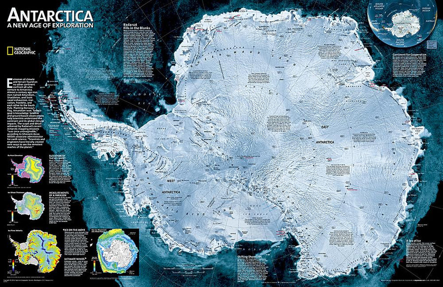
Playboard - Antarctica - 120 x 100 cm | Maps International

Panneau épinglable (en anglais) - Antarctique - 120 x 100 cm | Maps International panneau épinglable Maps International
Carte murale – Antarctique (en anglais) – 120 x 100 cm | Maps International - La Compagnie des Cartes
Panneau épinglable (en anglais) - Antarctique - 120 x 100 cm | Maps International panneau épinglable Maps International

Playboard - Antarctica - 120 x 100 cm | Maps International

Regular price $261.00
/
  • Custom-made product - Shipping within 7 to 10 working days from our workshop. For shipping outside France or Belgium, please contact us!
  • Delivery costs calculated instantly in the cart
Tax included.

Often purchased together:

Pointing Point of Political Antarctica (in English). Based on the data from the British Antarctic Survey. Land claims are displayed. The polar bases, weather stations, base camps and aerodromes are clearly indicated, as well as the contraction and expansion of ice in summer and winter. The map also includes an inset with factual information and detailed antarctic figures.
Dimensions 120 x 100 cm .

Note : An additional delay of a few days is necessary for the manufacture and packaging of this panel.

The delivery is ensured by carrier.

Manufacturing information : the Map is glued on a polystyrene plate (kapamount) and then laminatedized, which allows the use of dry felts and pins. The panel is finished in an aluminum frame with rounded gray color angles.


ISBN / EAN : PR.IM.EN.ANT
Date de publication : 2019
Echelle : 1/7,000,000 (1cm=70km)
Impression: front
Dimensions déplié(e) : 120x100cm
Langue : English
Poids : 5000 g

Customer Reviews

No reviews yet
0%
(0)
0%
(0)
0%
(0)
0%
(0)
0%
(0)
More from Antarctica
Carte de Antarctique | Reise Know How carte pliée Reise Know-How
General Map - Antarctica | Reise Know-How
Reise Know-How
$12.00
Carte de voyage - Antarctique & Terre de Feu | ITM carte pliée ITM
Travel Map - Antarctica & Terre de Fire | ITM
ITM
$15.00
Carte de randonnée n° 4460A - Iles Saint-Paul et Nouvelle Amsterdam | IGN - Série Bleue carte pliée IGN
Hiking Map # 4460a - Saint Paul Islands and New Amsterdam | IGN - Blue Series
IGN
$16.00
Carte de randonnée n° 4450C - Archipel de Crozet : îles Cochons, Apôtres, Pingouins | IGN - Série Bleue carte pliée IGN
Hiking Map # 4450C - Crozet Archipelago: Pigs Islands, Apostles, Penguins | IGN - Blue Series
IGN
$16.00
Recently viewed