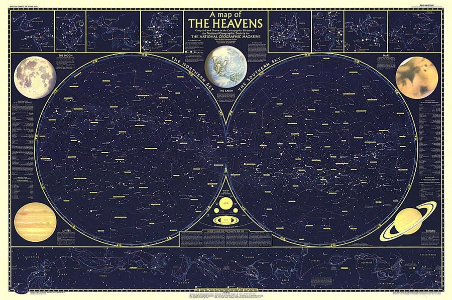
1957 Heavens

1957 Heavens Wall Map

1957 Heavens

Regular price $47.00
/
  • Ships within 48 business hours from our US warehouse.
  • Delivery costs calculated instantly in the cart
  • Free returns (*)
  • Real-time inventory
  • In stock, ready to ship
  • Inventory on the way
Tax included.

Often purchased together:

Published in December 1957, this map is half of a two-part map of the heavens that appeared with the article "How Man-made Satellites Can Affect Our Lives." It shows the constellations and brightest stars as seen from both the northern and southern hemispheres and also includes information on the planets including their relative size.


ISBN/EAN : 2321620M
Publication date: 1957
Unfolded dimensions: 42in / 28in
Language(s): English
Poids : 200 g

Customer Reviews

Be the first to write a review
0%
(0)
0%
(0)
0%
(0)
0%
(0)
0%
(0)
Carte murale (en anglais) - Antarctique satellite | National Geographic carte murale petit tube National Geographic Papier
Carte murale (en anglais) - Antarctique, vue de satellite - 77 x 52 cm | National Geographic carte murale petit tube National Geographic
Wall Map - Antarctica, Satellite View - 77 x 52 cm | National Geographic
National Geographic
from $33.00
Carte murale (en anglais) - La Lune | National Geographic carte murale petit tube National Geographic Papier
Carte murale (en anglais) - La Lune - 108 x 73 cm | National Geographic carte murale petit tube National Geographic
Wall Map - The Moon - 108 x 73 cm | National Geographic
National Geographic
from $39.00
Carte murale (en anglais) - L'Univers | National Geographic carte murale petit tube National Geographic Papier
Carte murale (en anglais) - L'Univers - 79 x 51 cm | National Geographic carte murale petit tube National Geographic
Wall Map - The Universe - 79 x 51 cm | National Geographic
National Geographic
from $34.00
Recently viewed