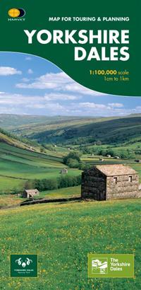
Carte de plein-air - Yorkshire Dales Touring, Nidderdale Area of NB | Harvey Maps carte pliée Harvey Maps

Outdoor map - Yorkshire Dales Touring, Nidderdale Area of ​​NB | HARVEY MAPS

Outdoor map - Yorkshire Dales Touring, Nidderdale Area of ​​NB | HARVEY MAPS

Regular price $15.00
/
  • Shipping within 24 working hours from our warehouse in France
  • Delivery costs calculated instantly in the basket
  • Free returns (*)
  • Real-time inventory
  • In stock, ready to ship
  • Backordered, shipping soon
Tax included.
Special map for outdoor activities published by Harvey Maps.
Original description of the publisher:

Map of the Whole National Park and Nidderdale Area of ​​Outstanding National Beauty.

Includes Town Plans of Richmond, Hawes, Leyburn, Pateley Bridge, Sedbergh. Kirkby Lonsdale, Ingleton, Settle, Skipton, Grassington. USEFUL PHONE NUMBERS AND INFORMATION ON VISITOR Attractions.


ISBN/EAN : 9781851374335
Publication date: 2014
Scale: 1/100,000 (1cm=1km)
Printed sides: front
Folded dimensions: 11.6 x 24.3cm
Language(s): English
Poids : 82 g

Customer Reviews

No reviews yet
0%
(0)
0%
(0)
0%
(0)
0%
(0)
0%
(0)