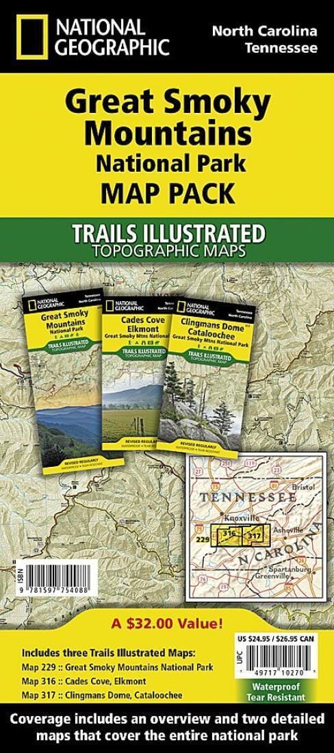
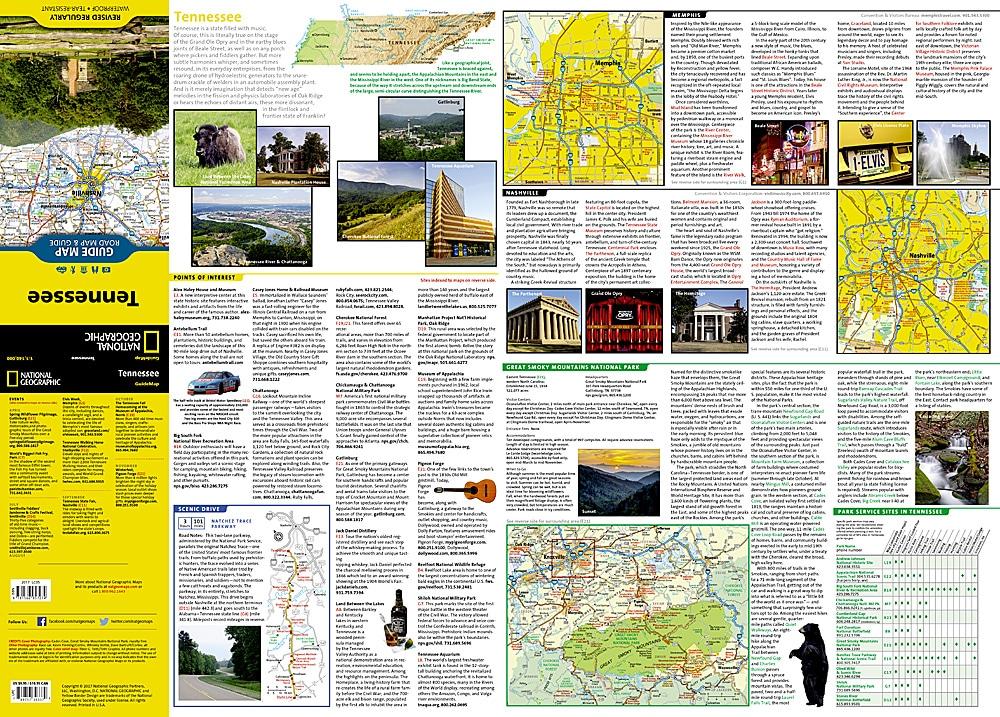
Trails Maps of Great Smoky Mountains National Park (North Carolina, Tennessee), # 229, 316, 317 (Pack Bundle) | National Geographic

Trails Maps of Great Smoky Mountains National Park, North Carolina & Tennessee - # 229, # 316, # 317 (Pack Bundle) | National Geographic

Trails Maps of Great Smoky Mountains National Park (North Carolina, Tennessee), # 229, 316, 317 (Pack Bundle) | National Geographic

Regular price $40.00
/
  • Ships within 48 business hours from our US warehouse. For this product, customs fees may be requested by the carrier upon delivery.
  • Delivery costs calculated instantly in the cart
  • Free returns (*)
  • Real-time inventory
  • In stock, ready to ship
  • Inventory on the way
Tax included.

Trail Maps of Great Smoky Mountains National Park (North Carolina & Tennessee) published by National Geographic.
Great Smoky Mountains National Park is the most visited national park in the country. The Map Pack Bundle includes three maps to help visitors get the most out of their trip.
The map pack includes an overview map that shows the entire park as well as two detailed maps of the east and west halves of the park. With this combination of maps visitors can feel comfortable planning a trip that includes driving the picturesque Cades Cove Driving Loop to hiking deep into the backcountry. All trails are marked with trail milage and all three maps include multiple points of interest such as quite walkways, campgrounds, boat launches, shelters and more.
Coverage includes: Great Smoky Mountains National Park, Appalachian Trail, Benton Mackaye Trail, Mountains-to-Sea Trail, Cades Cove Driving Loop, Chilowee Mountain, Little Mountain, Cataloochee Divide, Blue Ridge Parkway, Cherokee, Pisgah and Nantahala National Forests, Little Tennessee and Tuckasegee Rivers, Chilhowee and Fontana Lakes, and more.
The Great Smoky Mountains National Park Map Pack includes:
Map 229 - Great Smoky Mountains National Park
Map 316 - Cades Cove, Elkmont: Great Smoky Mountains National Park
Map 317 - Clingmans Dome, Cataloochee: Great Smoky Mountains National Park

These trail maps are waterproof and tear-resistant.


ISBN/EAN : 9781597754088
Publication date: 2014
Scale: multiple
Printed sides: both sides
Folded dimensions: 9.45 inches x 4.33 inches (24 x 11 cm)
Unfolded dimensions: 24.8 x 37.01 inches (63 x 94cm)
Waterproof: oui
Tear resistant: oui
Language(s): English
Poids : 340 g

Customer Reviews

Be the first to write a review
0%
(0)
0%
(0)
0%
(0)
0%
(0)
0%
(0)
Carte routière - Caroline du Nord (USA) | National Geographic carte pliée National Geographic
Road Map - North Carolina (USA) | National Geographic
National Geographic
$13.00
Carte routière - Tennessee | National Geographic carte pliée National Geographic
Road Map - Tennessee | National Geographic
National Geographic
$13.00
Carte de voyage - Sud-est des USA | National Geographic - La Compagnie des Cartes
Travel Map - South-East US | National Geographic
National Geographic
$18.00
Carte de voyage - Sud-est des USA | National Geographic carte pliée National Geographic
Travel Map - South-East US | National Geographic
National Geographic
$13.00
Recently viewed