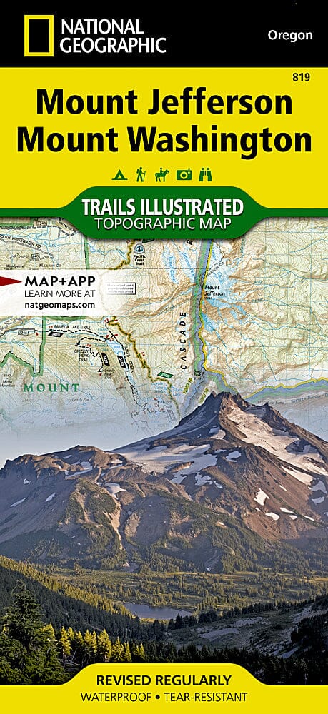
National Geographic Trail Map of the Mount Jefferson and Mount Washington Wilderness Area (Oregon).
The Mount Jefferson and Mount Washington Wilderness Areas are characterized by scenic mountains, glaciers, alpine meadows, pine and fir forests, and more than 175 lakes.
National Geographic's Trails Illustrated Mount Jefferson and Mount Washington map features key points of interest, including the Menagerie Wilderness Area, Detroit, Suttle, Clear, Marion, and Blue River lakes, the McKenzie and Metolius rivers, and the Santiam Pass Summer OHV Area.
.
With hundreds of miles of mapped trails, including portions of the Pacific Crest National Scenic Trail, the Metolius-Windigo Trail, and the Lava River National Recreation Trail, this map can guide you off the beaten path and back on it. Trail use is easy to identify, whether you're hiking, biking, horseback riding, or OHVing. The McKenzie Pass-Santiam Pass and West Cascades scenic drives are marked for those who want to take in the scenery by car. Numerous recreational features are also marked, including campgrounds, horse camps, boat launches, waterskiing and swimming areas, whitewater access points, ski resorts, terrain parks, interpretive sites, and points of interest. The basemap includes contour lines and elevations for peaks and passes.
This is a base map.
Other features found on this map include: Black Butte, Cougar Reservoir, Deschutes National Forest, Detroit Lake, Green Ridge, Middle Santiam Wilderness, Mount Jefferson, Mount Jefferson Wilderness, Mount Washington Wilderness, Three Sisters Wilderness, and Willamette National Forest.
This topographic map is waterproof and tear-resistant.
Scale 1:75,000.