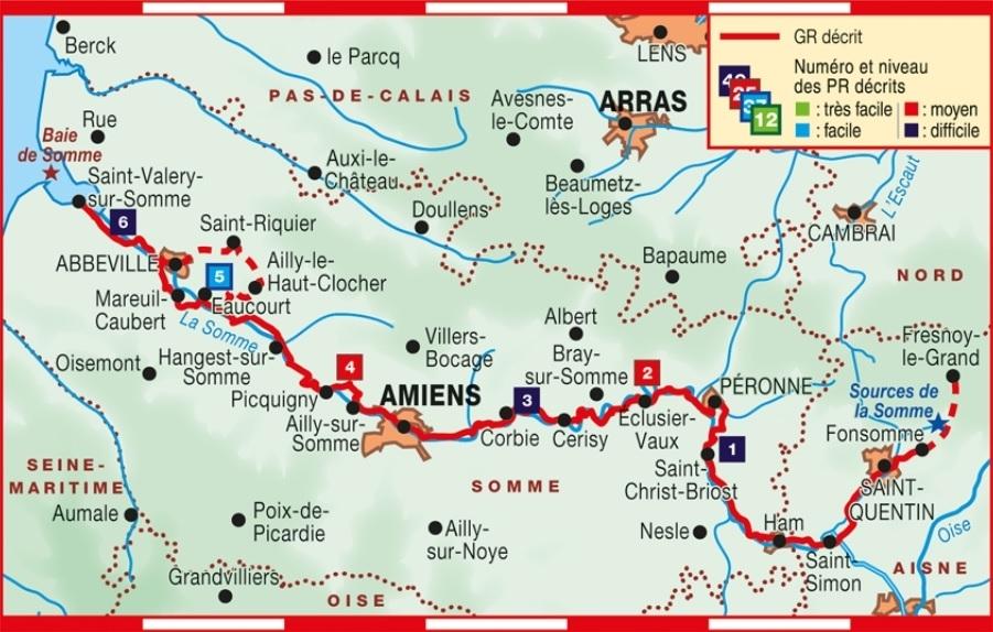
Topoguide de randonnée - Au fil de la Somme GR 600 | FFR guide de randonnée FFR - Fédération Française de Randonnée

Hiking Topoguide - GR 600 | FFR (French)

Hiking Topoguide - GR 600 | FFR (French)

Regular price $19.00
/
  • Shipping within 24 working hours from our warehouse in France
  • Delivery costs calculated instantly in the basket
  • Free returns (*)
  • Real-time inventory
  • In stock, ready to ship
  • Backordered, shipping soon
Tax included.

Topoguide of the "Great hiking" collection. More than 180 km of Paths Gr.

The GR® 800 takes place over the sum, from the source of the Pimap River, in the Aisne, until the sea, crossing the entire eponymous department from east to west.

The route allows you to connect the belveders and discover beautiful points of view or penetrate the aquatic environments, bird paradise, hunters, fishermen and hikers.

The cities met - Saint-Quentin, Ham, Péronne, Amiens, Abbeville, Saint-Valery - Are all places loaded with history.


ISBN/EAN : 9782751410116
Publication date: 2018
Pagination: 112 pages
Folded dimensions: 21 x 13.5cm
Language(s): French
Poids : 180 g

Customer Reviews

Based on 1 review
100%
(1)
0%
(0)
0%
(0)
0%
(0)
0%
(0)
E
EC (Lyon, FR)
Précis et complet. Pratique.

Manque juste la possibilité de charger gratuitement les .GPX associé sur un site avec l'achat du livre. Sinon parfait