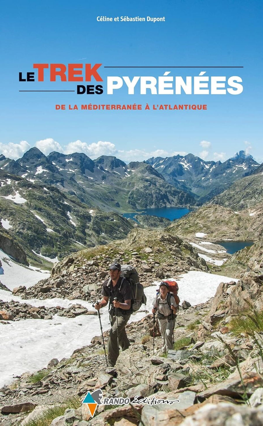
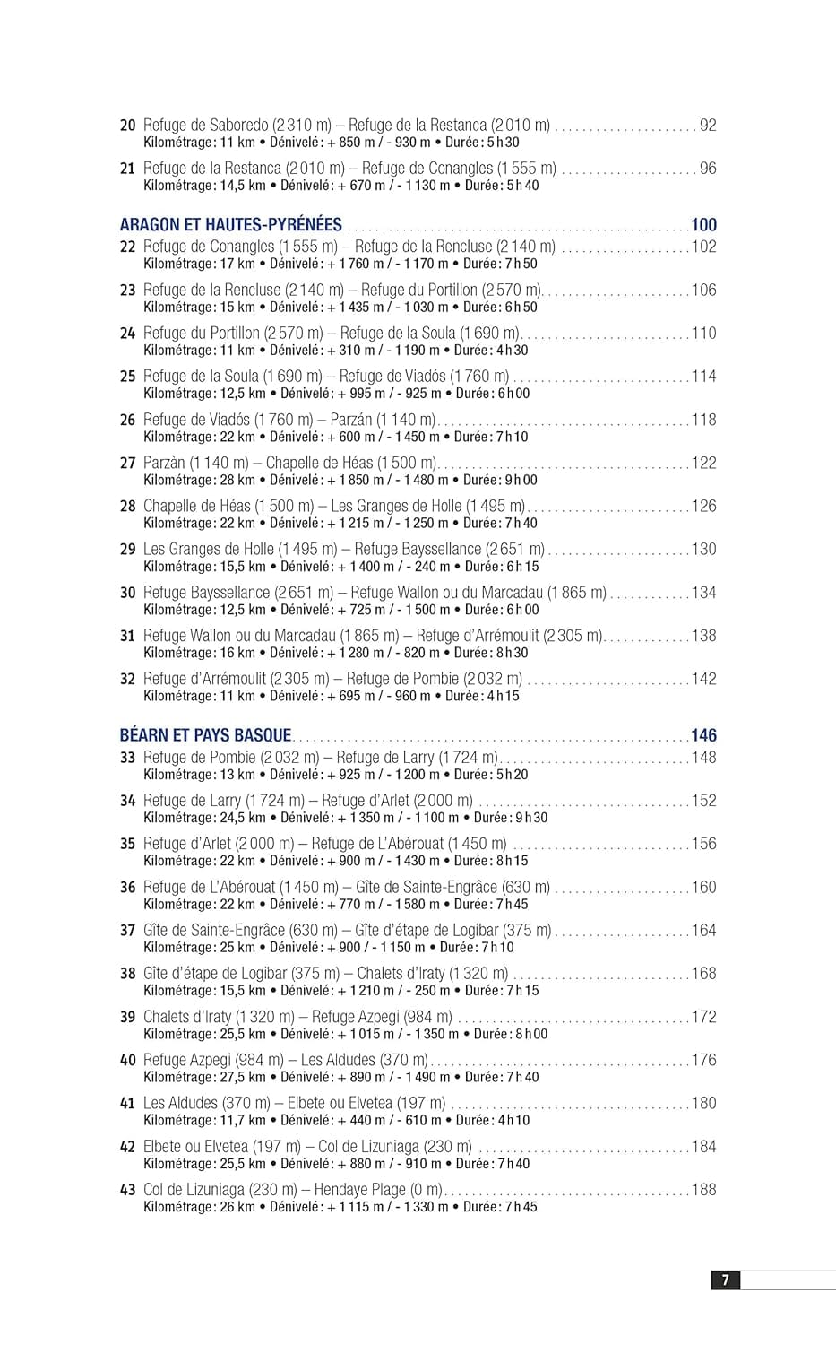
Hiking Guide - Trek des Pyrenees, the Atlantic Mediterranean | Rando Editions (French)

Guide de randonnée - Trek des Pyrénées, de la Méditerranée à l'Atlantique | Rando Editions guide de randonnée Rando Editions

Hiking Guide - Trek des Pyrenees, the Atlantic Mediterranean | Rando Editions (French)

Regular price $23.00
/
  • Shipping within 24 working hours from our warehouse in France
  • Delivery costs calculated instantly in the cart
  • Free returns (*)
  • Real-time inventory
  • In stock, ready to ship
  • Inventory on the way
Tax included.

Often purchased together:

A new big crossing of the Pyrenees! From east to west, following sometimes (upside down) the route of the GR 10 and / or the HRP, sometimes (at the place) that of the GR 11, elsewhere a itinerary which is singular, this trek in 43 Steps proposes a vertical flower adventure, in a grandiose decor where the hiker rubs next to the Canigou, Carlit, Mont Rouch, the Park of Aigüestortes, the Massif de la Sicktta and the aneeto, the posets, Barroude, the circuses From Troumouse and Gavarnie, the vineyard, the Balatyous massif, the Ossau, the arres of the anie, the forest of Iraty ...


Steps (with halt in refuge most often) between 4:30 and 9:00, with positive vertells oscillating between 300 and 1800 (!) M. Some truly difficult stages (15, 22, 27, 34).

A precise, detailed, well-informed guide, fruit of three years of summer work.


ISBN/EAN : 9782841825660
Publication date: 2015
Folded dimensions: 23x14cm
Language(s): French
Poids : 431 g

Customer Reviews

Based on 1 review
100%
(1)
0%
(0)
0%
(0)
0%
(0)
0%
(0)
d
didier c. (Paris, FR)
excellent

guide très pertinent, performant et pratique

More from Rando Editions
Carte générale touristique - Pyrénées | Rando Editions carte pliée Rando Editions
General Tourist Map - Pyrenees | Rando Editions (French)
Rando Editions
$13.00
Carte de randonnée n° 1 - Pays Basque Ouest (Labourd, Basse-Navarre) | Rando Editions carte pliée Rando Editions
Hiking Map # 1 - West Basque Country (Labourd, Lower Navarre) | Rando Editions (French)
Rando Editions
$17.00
Carte de randonnée n° 2 - Pays Basque Est (Pyrénées) | Rando Editions carte pliée Rando Editions
Hiking Map # 2 - Basque Country East (Pyrenees) | Rando Editions (French)
Rando Editions
$17.00
Carte de randonnée du Béarn (Pyrénées), n°3 | Rando Editions - La Compagnie des Cartes
Hiking Map # 3 - Béarn (Pyrenees) | Rando Editions (French)
Rando Editions
$17.00
Carte de randonnée n° 4 - Bigorre (Pyrénées) | Rando Editions carte pliée Rando Editions
Hiking Map # 4 - Bigorre (Pyrenees) | Rando Editions (French)
Rando Editions
$17.00
Recently viewed