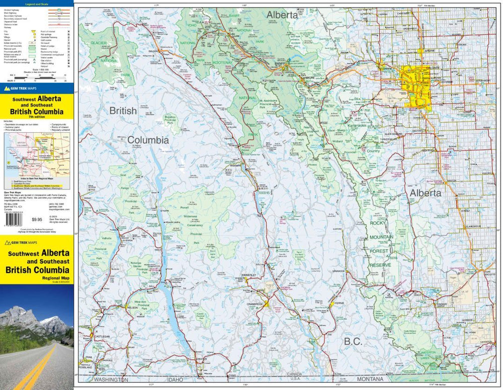
Road Map - Alberta Southwest & British Columbia South East | Gem Trek

Carte routière - Alberta Sud-Ouest & Colombie Britannique Sud-Est | Gem Trek carte pliée Gem Trek Publishing
Carte routière - Alberta Sud-Ouest & Colombie Britannique Sud-Est | Gem Trek - La Compagnie des Cartes

Road Map - Alberta Southwest & British Columbia South East | Gem Trek

Regular price $14.00
/
  • Shipping within 24 working hours from our warehouse in France
  • Delivery costs calculated instantly in the cart
  • Free returns (*)
  • Real-time inventory
  • In stock, ready to ship
  • Inventory on the way
Tax included.

Often purchased together:

Southwestern Alberta and South-East Road Map of British Columbia (Canada) published by Gem Trek.

This map is designed for Visitors who wish to explore the regions in the east and west of the Canadian Rockies, including the Kootenays of British Columbia, the foothills of Alberta and the west-central Alberta.

All major highways are indicated, as well as national and provincial parks and wild areas. The map also shows less known secondary roads and indicates the location of lodges, campsites and hot springs. Mileage tables indicate the distances between the main cities.
This double-sided map from southwestern Alberta and southeast British Columbia divides the region into two halves. Although we used the nickname "southwestern Alberta", this map extends to the north of the provincial capital of Edmonton, which is approximately the geographical center of Alberta. On this side of the map, the cover extends to the west to Jasper National Park and the south to Saskatchewan River Crossing and Crossfield and Carstair cities in Alberta. The back of these same cities south of Calgary to the city of Fort Macleod south of Alberta and the American and west border at Banff National Park at the Glacier National Park on the Trans-Canada Highway and also To the west with the cities of Nelson and Castlegar in British Columbia.

Table of distances, indication of national or provincial parks and reserves, accommodation sites (campsites, hotels) etc ...


ISBN/EAN : 9781895526936
Publication date: 2020
Scale: 1/500,000 (1cm=5km)
Printed sides: both sides
Folded dimensions: 24.7 x 11.5 x 0.5cm
Unfolded dimensions: 79 x 62cm
Language(s): English
Poids : 43 g

Customer Reviews

Based on 3 reviews
100%
(3)
0%
(0)
0%
(0)
0%
(0)
0%
(0)
j
jeannine c. (Nice, FR)
Colombie britannique

je me suis trompée de région. C'était vraiment plus au nord. Je me suis arrangé autrement pour faire mon album. Merci

J
Jean-Paul S. (Colmar, FR)
TB

Correspond à ce que j'attendais

M
Michèle M.
Parfait pour préparer notre voyage. ...

Parfait pour préparer notre voyage. Carte très lisible et très complète

More from Western Canada
Guide de voyage - Ouest canadien et Ontario | Lonely Planet guide de voyage Lonely Planet 2022
Travel Guide - West Canadiens and Ontario - 2020 Edition | Lonely Planet (French)
Lonely Planet
$30.00
Nouveauté
Guide du Routard - Canada Ouest 2024/25 | Hachette guide de voyage Hachette
Routard Guide - Canada West 2020/21 | Hachette (French)
Hachette
$20.00
Guide de voyage - Vancouver + plan | Petit Futé guide de voyage Petit Futé
Travel Guide - Vancouver + Plan | Petit Futé (French)
Petit Futé
$17.00
Sold Out
Carte de randonnée - Parc National des Lacs Waterton | Gem Trek carte pliée Gem Trek Publishing
Hiking Map - Waterton Lakes National Park | Gem Trek
Gem Trek Publishing
$18.00
Sold Out
Atlas routier de poche – Canada Nord et Ouest | ITM - La Compagnie des Cartes
Pocket Road Atlas - Canada North and West | ITM
ITM
$19.00
Recently viewed