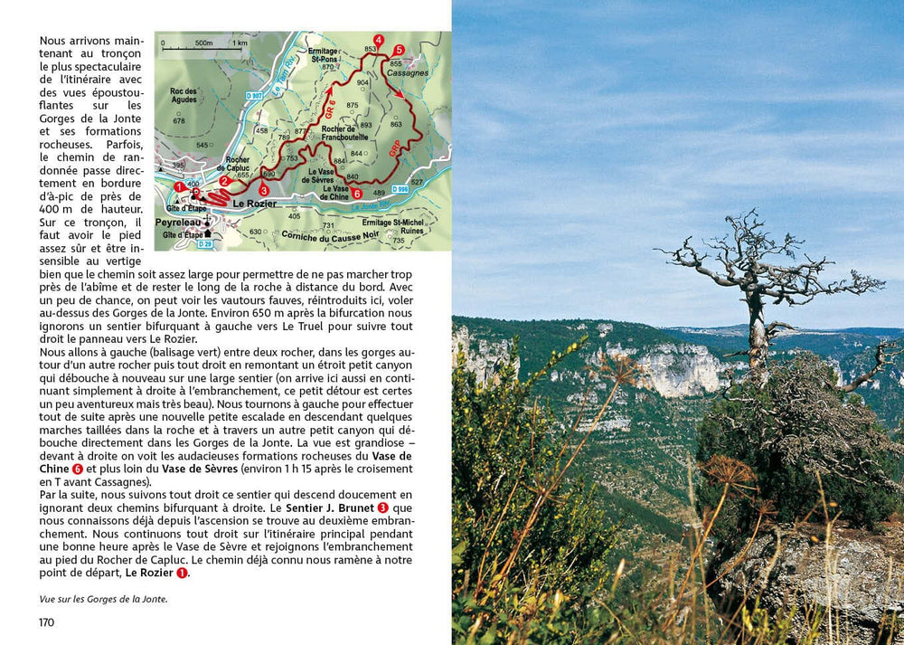
Topocarte - Cévenol and Tanargue: In the heart of the Cévennes d'Ardèche | FFRandonnée

Price
Regular price $15.00
Regular price Sale price $15.00
Save $-15
/
  • Product on order - Shipping within 5 to 8 working days from our warehouse in France
  • Delivery costs calculated instantly in the basket
Tax included.

Often purchased together:

This map is based on two GR® de Pays trails: the Cévenol and the Tanargue. 160 kilometers of hiking between granite chaos, mule trails, and mountainous landscapes.

  • The Cévennes is a 6-day linear route starting from La Bastide-Puylaurent. For this GRP, a 4-day loop route starting from La Bastide-Puylaurent is possible.
  • The Tanargue is a 4-day loop starting from Largentière.

In 2025, the map will evolve: a softened four-color process and reinforced paper (still rainproof!). The GPX track and a selection of accommodation and useful addresses remain accessible via MaRando, the FFRandonnée application.
The topocarte is the essential and practical tool to simplify roaming.

Main sites: Mont d'Ardèche Regional Natural Park, Cévennes, Tanargue Massif, Méjean Summit, Bastide-Puylaurent


ISBN / EAN : 9782751413704
Date de publication : 2025
Echelle : 1/50,000 (1cm=500m) & 1/30,000
Impression: both sides
Dimensions plié(e) : 25 x 10.7 x 0.3 cm
Langue : French
Poids : 80 g

Customer Reviews

Be the first to write a review
0%
(0)
0%
(0)
0%
(0)
0%
(0)
0%
(0)