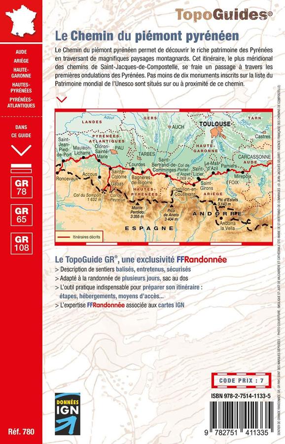
Hiking Topoguide - Piedmont Pyrenean Road to St Jacques de Compostela (Carcassonne, Lourdes, Roncevaux) - GR78 | FFR (French)

Topoguide de randonnée - Le chemin du piémont pyrénéen vers St jacques de Compostelle (Carcassonne, Lourdes, Roncevaux) - GR78, GR65, GR108 | FFR guide de randonnée FFR - Fédération Française de Randonnée

Hiking Topoguide - Piedmont Pyrenean Road to St Jacques de Compostela (Carcassonne, Lourdes, Roncevaux) - GR78 | FFR (French)

Regular price $21.00
/
  • Shipping within 24 working hours from our warehouse in France
  • Delivery costs calculated instantly in the cart
  • Free returns (*)
  • Real-time inventory
  • In stock, ready to ship
  • Inventory on the way
Tax included.
Topoguide of the "Great hiking" collection with detailed maps for hiking on the path of Piedmont Pyrenean to St Jacques de Compostela. still little known, less frequented than the path of Puy and widely modeled On ancient Roman roads, the path of Piedmont Pyreneen is a very nice alternative to discover the rich heritage of the Pyrenees by crossing magnificent mountain landscapes.
The route, the southernmost of the paths of Saint Jacques, connects The Atlantic Mediterranean by running from east to west, the Razes, the Ariège, Comminges, Bigorre, the country of the Gaves. North-South axes provide access to the crossing passes of the Pyrenees by the valleys of Aure, from Ossau, from Aspe (Pass of the Somport to the Aragon) and in Saint-Jean-Foot-de -Port (Ronceval Pass to Navarre).
It is a little known and rich innovative adventure path that can be reached by leaving the Way of Arles in Montpellier towards Narbonne by Saint-Thibéry and Beziers (via domitia).


ISBN/EAN : 9782751411335
Publication date: 2022
Pagination: 152 pages
Folded dimensions: 21x13cm
Language(s): French
Poids : 225 g

Customer Reviews

No reviews yet
0%
(0)
0%
(0)
0%
(0)
0%
(0)
0%
(0)
More from Lourdes
Carte TOP 25 n° 1647 ET - Lourdes, Argelès-Gazost & le Lavedan (Pyrénées) | IGN carte pliée IGN
Map top 25 # 1647 ET - Lourdes, Argelès-Gazost & Le Lavedan (Pyrenees) | IGN
IGN
$16.00
Carte départementale n° 342 - Hautes-Pyrénées & Pyrénées-Atlantiques | Michelin carte pliée Michelin
Departmental Map # 342 - Hautes-Pyrénées & Pyrénées-Atlantiques | Michelin (French)
Michelin
$8.00
Sold Out
Carte TOP 200 n° 205 - Pyrénées Ouest | IGN carte pliée IGN
Map top 200 # 205 - Pyrenees West | IGN
IGN
$9.00
Carte routière n° 145 - Pyrénées Centrales (Béarn, Bigorre, Aragon) | Michelin carte pliée Michelin
Carte routière n° 145 - Pyrénées Centrales (Béarn, Bigorre, Aragon) | Michelin - Zoom Espagne carte pliée Michelin
Road Map # 145 - Pyrenees Central (Béarn, Bigorre, Aragon) | Michelin - Zoom Spain (French)
Michelin
$10.00
Carte de randonnée des Pyrénées Centrales | TerraQuest - La Compagnie des Cartes
Carte de randonnée plastifiée - Pyrénées Centrales | TerraQuest carte pliée Terra Quest
Laminated Hiking Map - Pyrenees Central | Terraquest
Terra Quest
$18.00
Recently viewed