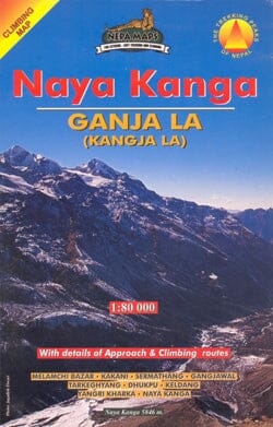
Roads from Kathmandu to the Langtang Valley, with an enlargement for the Naya Kanga massif, in the Nepa Maps series, which offers extensive coverage of Nepal's trekking areas on detailed contour maps with trekking routes and hiking trails, huts and campsites, local places of interest, and other tourist information.
The map is based on topographical surveys of the country, with contour lines generally at 40m or 50m intervals, enhanced by relief shading, coloring, and graphics to show various terrain features, including glaciers, forested or cultivated areas, etc. Many peaks, with additional elevation points, as well as the names of glaciers and mountain ranges, are clearly visible. The network of rivers, streams, and lakes is shown in great detail, with many smaller streams and named lakes.
The overlay highlights the main trekking routes and many local trails, with symbols indicating various places of interest and tourist facilities. Most maps are indexed and include additional information such as route profiles, glossaries, etc. All information is in English, and elevations are given in meters.
*In this title:* the area between the outskirts of Kathmandu and the Langtang Valley, including the Kangja La Pass, Naya Kanga, and the Shivapuri Watershed and Wildlife Sanctuary. The contour lines are at 125 m intervals, with relief shading and vegetation coloring. The index lists places, peaks, lakes, and passes. The margin ticks indicate latitude and longitude at 5' intervals. Additional information includes an inset showing the Naya Kanga massif at 1:80,000 with the route to the summit from Langtang Valley, a profile of the route from Melamchi Bazar to Naya Kanga, plus tables showing the staged routes with altitudes in meters and feet and trekking times.