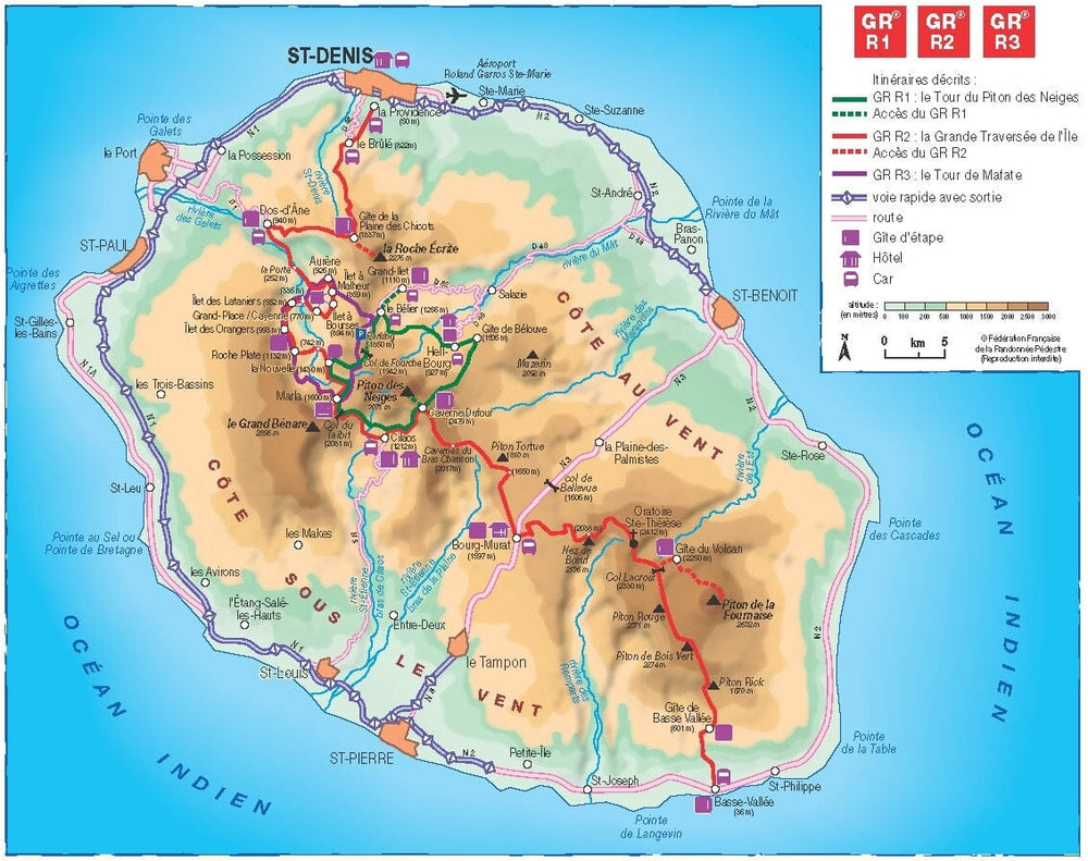
Hiking topoguide - Tours and crossing of Reunion Island - GR R1/R2/R3 | FFR

Price
Regular price $21.00
Regular price Sale price $21.00
Save $-21
/
  • Shipping within 24 working hours from our warehouse in France
  • Delivery costs calculated instantly in the basket
  • Free returns (*)
  • Real-time inventory
  • In stock, ready to ship
  • Backordered, shipping soon
Tax included.

Often purchased together:

Topoguide from the “Grandehike” Collection with detailed information sheets for discovering Reunion Island. More than 23 days of hiking on the 3 GR ® of Reunion to go around the Piton des Neiges, the great crossing of the island from north to south and around the Mafate cirque.

Pitons, volcanoes and cirques in the Hauts, beaches and cliffs in the Bas, the royal "Isle Bourbon" of explorers is draped in all its beauties in the heart of the Indian Ocean.

This beautiful tropical Creole, named Reunion Island in 1793, displays its plant dress embroidered with colorful tamarinds, pinpins, camphor trees, casuarinas and orchids.

This topoguide presents the 3 GR ® crossing the island by land: the GR ® R1 to go around the Piton des Neiges, the highest peak on the island (3,071 meters); the GR ® R2 allowing you to make the long crossing of the island, from North to South from Saint-Denis to Basse-Vallée; the GR ® R3 to go around the Mafate cirque.


ISBN/EAN : 9782751412844
Publication date: 2023
Pagination: 160 pages
Folded dimensions: 21 x 13.5cm
Language(s): French
Poids : 200 g

Customer Reviews

Be the first to write a review
0%
(0)
0%
(0)
0%
(0)
0%
(0)
0%
(0)
CampingCard ACSI - Carte de réductions & Guide - Europe 2024 guide pratique ACSI
CampingCard ACSI - Carte de réductions & Guide - Europe 2022 guide pratique ACSI
CampingMap ACSI - Discounts Map & Guide - Europe (French)
ACSI
$25.00
Guide - Randonner aux îles Lofoten guide de randonnée Topo Guide Lofoten
Guide - Hiking to the Lofoten Islands
Topo Guide Lofoten
$33.00
Guide de randonnée - Madère | Rother guide de randonnée Rother
Guide de randonnée - Madère | Rother guide de conversation Rother
Hiking guide - Madeira | Rother (French)
Rother
$21.00
Guide de randonnée - Ténérife | Rother guide de randonnée Rother
Hiking guide - Tenerife | Rother (French)
Rother
$21.00
CampingCard ACSI - Carte de réductions & Aires camping-cars Europe 2024 guide pratique ACSI
CampingCard ACSI - Carte de réductions & Aires camping-cars Europe 2022 guide pratique ACSI
CampingMap ACSI - Map of Discounts & Aires Campsite Europe (French)
ACSI
$34.00