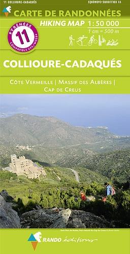
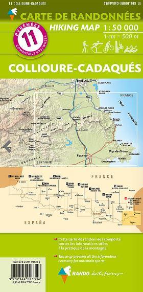
Cartes & Guide de randonnée - Sender de la Mediterrania GR92 Nord (Catalogne) | Alpina carte pliée Editorial Alpina

Hiking Map - Porta del Cel | Alpina

Hiking Map - Porta del Cel | Alpina

Regular price $34.00
/
  • Shipping within 24 working hours from our warehouse in France
  • Delivery costs calculated instantly in the basket
  • Free returns (*)
  • Real-time inventory
  • Low stock - 2 items left
  • Backordered, shipping soon
Tax included.

La Porta del Cel is a high mountain circuit in the heart of Pallars Sobirà, connecting four shelters: Campan, Pinet, Vallferrera and Camping de Graus, in addition to crossing the city of Tavascan and take a ride at a time at a time to through the Natural Park of Alt Pirineu and through the

Regional Natural Park of the Ariege Pyrenees.
The difference in accumulated height (mounted and descent) is greater than 11,000 m and the distance varies from 65 km, so it must be transported the minimum necessary for an excursion in high mountains.

  • topographic map at 1:25 000
  • Step Refuge
  • technical sheet
  • Altitude profile
  • Practical Tips


ISBN/EAN : 9788490344729
Publication date: 2016
Scale: 1/50,000 (1cm=500m)
Printed sides: front
Folded dimensions: 21 x 12.5cm
Language(s): Catalan
Poids : 500 g

Customer Reviews

Based on 1 review
100%
(1)
0%
(0)
0%
(0)
0%
(0)
0%
(0)
M
Murielle S. (Foix, FR)
Génial!!!

J'ai acheté ce livre afin de pouvoir compléter mon parcours débuté à Collioure et achevé à Blanès;j'ai donc trouvé ce topo qui permet de continuer jusqu'au Baixador de Vallvidrera et grace au train FGC de visiter Barcelone....Le topo,bien qu'écrit en catalan,est facile à traduire...et est très précis et exact sur le terrain!Royal!!!