Wind River Range - North - Wyoming | Beartooth Publishing Hiking Map

Wind River Range - North - Wyoming | Beartooth Publishing

Wind River Range - North - Wyoming | Beartooth Publishing

Regular price $19.00
/
  • Ships within 48 business hours from our US warehouse.
  • Delivery costs calculated instantly in the basket
  • Free returns (*)
  • Real-time inventory
  • In stock, ready to ship
  • Backordered, shipping soon
Tax included.

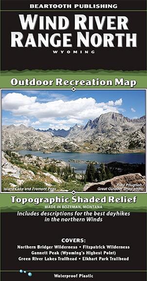
The definitive trail maps for the Wind River Range since 2010, our Wind River North and South maps were completely remade in 2020. The new editions include new trail data, more recreation sites, and new cartographic art styles. The maps’ detail shows every little lake, creek, and wetland.

This Wind River Range North map covers from the Trail Lake Road just south of Dubois to the highway junction at Boulder. All recreation access roads leaving Pinedale are clearly noted. This map also includes descriptions for five of the best dayhikes in the northern Winds.


ISBN/EAN : 9781887460200
Publication date: 2020
Folded dimensions: 8.27 x 4.330 inches / 21 x 11 cm
Unfolded dimensions: 38.58 x 24.410 inches / 98 x 62 cm
Language(s): English
Poids : 60 g

Customer Reviews

Based on 2 reviews
50%
(1)
50%
(1)
0%
(0)
0%
(0)
0%
(0)
J
John B. (Duluth, US)

Waterproof map. Good definition. Used to plan future trip.

R
Robert S.
Great Map

A high-quality, durable and beautifully illustrated map. If it’s as good as the southern map of the Winds, which I used in our group’s 13-day trip from Big Sandy to Pole Creek last summer, it should be reliably accurate. Buy it!